You can now jog or cycle along the new 18km recreational route connecting East Coast Park to Pasir Ris Park


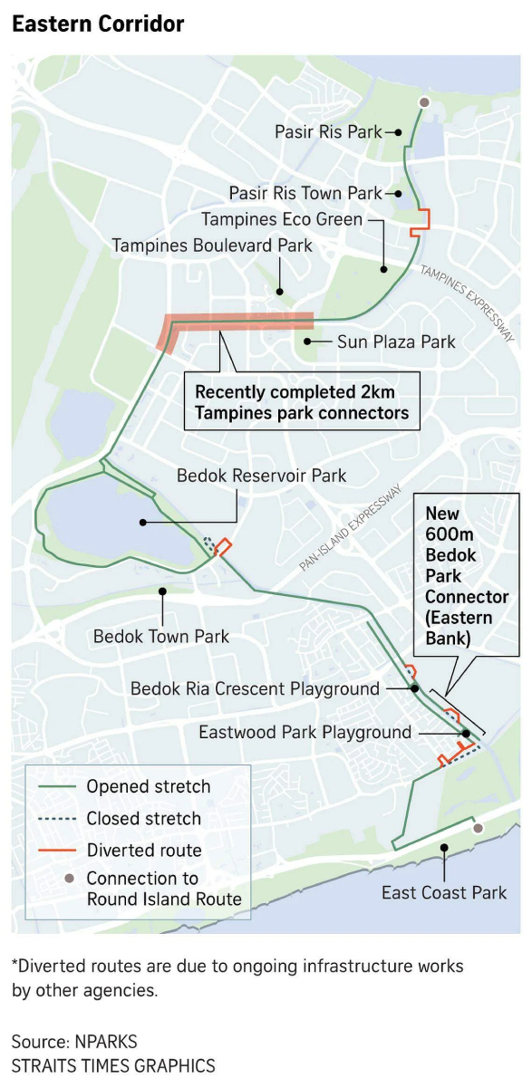
SINGAPORE — Residents and visitors now have an alternative route for jogging or cycling between Pasir Ris Park and East Coast Park through Bedok Reservoir Park, with the completion of the 18km Eastern Corridor.
The National Parks Board (NParks) on Feb 17 opened the new 600m Bedok Park Connector (Eastern Bank) along the Sungei Bedok waterway, which completes the Eastern Corridor.
The recreational green route also features the recently completed park connectors along Tampines Avenue 9 and Tampines Avenue 10, which together with the new Bedok park connector total over 3.2km.
NParks also announced three new cycling bridges planned along the eastern half of the Round Island Route at Changi Beach Park and East Coast Park.
There are plans for the three bridges to be built across Changi Creek, connecting Changi Point to Changi Beach Park, as well as the eastern end of East Coast Park, and to replace the existing bridge across Fort Road at the western end of East Coast Park.
NParks said these are part of its efforts to expand connectivity across Singapore, providing more opportunities for the community to explore nature areas.
"They also contribute towards enabling every household to live within a 10-minute walk of a park by 2030," NParks added in a statement.
The Eastern Corridor was first announced in 2021 and was progressively opened.
Its completion links up several parks which offer experiences such as bird watching at Tampines Eco Green, a therapeutic garden at Sun Plaza Park and sports activities at East Coast Park.
Half of the route is located along waterways such as Sungei Tampines.
The recently completed park connectors along Tampines link up Tampines Eco Green and Bedok Reservoir Park.
The eastern half of the Round Island Route, opened in January 2022, will be enhanced with mapboards and directional signage, as well as landscaping to provide shade and greenery.
NParks will also introduce marine habitats by installing tiles that support marine life, in order to attract biodiversity along the route.
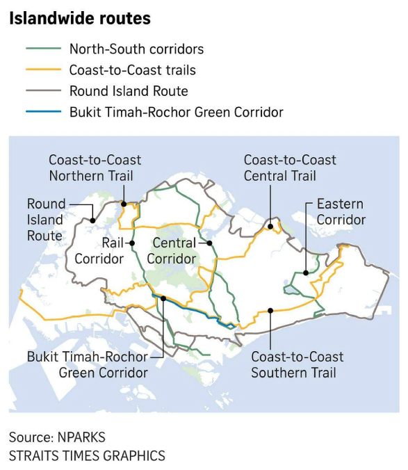
Currently, at 75km, the Round Island Route is the island's longest recreational connection, stretching from Rower's Bay Park in the north-east, to Changi Beach Park, East Coast Park and past the Singapore River to Berlayer Creek near Labrador Nature Reserve in the south.
The rest of the Round Island Route, which will come up to 150km in total, will be progressively completed by 2035.
"These are part of NParks' overall plans to curate a 360km island-wide network of recreational routes by 2035, as Singapore transforms into a City in Nature," said NParks.
Deputy Prime Minister Heng Swee Keat, who announced the completion of the Eastern Corridor on Feb 17, said: "Since 2021, residents here and across Singapore have been enjoying recreational activities along parts of the Eastern Corridor, bringing them closer to nature."
"By bringing families, friends and neighbours together, shared spaces like these help to create a more caring, green and vibrant community here at East Coast," he said.
"Families and friends can spend time with one another along the Eastern Corridor, forging special memories across generations."
One of the residents who will benefit is Joanna Cheong, who lives in Bedok North.

She and her husband take their daughters, aged six and 14, outdoors every weekend. Her husband would cycle 20km with their girls while she walks 10km with her mother.
"It's their only chance to be outdoors, since they're usually in school or at home," said the 39-year-old, who works as a patient service associate.
"It gets them to stop looking at their phone," she added.
"Sometimes, they complain it's hot. But they still come along. When we sweat, it really improves our mood."

ALSO READ: Enhancing amenities, connectivity and more: The transformation of Bukit Merah and 13 southern parks
This article was first published in The Straits Times. Permission required for reproduction.